

You can find on this page the Mumbai - Bombay old map to print and to download in PDF. The Mumbai - Bombay historical map and the vintage map of Mumbai - Bombay present the past and evolutions of the city of Mumbai - Bombay in Maharashtra - India.
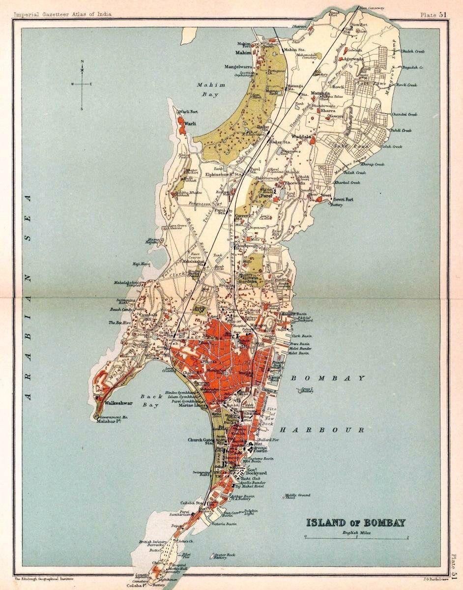
The Mumbai - Bombay old map shows evolutions of Mumbai - Bombay city. This historical map of Mumbai - Bombay will allow you to travel in the past and in the history of Mumbai - Bombay in Maharashtra - India. The Mumbai - Bombay ancient map is downloadable in PDF, printable and free.
The Mughal Empire, founded in 1526, was the dominant power in the Indian subcontinent during the mid-16th century. Growing apprehensive of the power of the Mughal emperor Humayun, Sultan Bahadur Shah of the Gujarat Sultanate was obliged to sign the Treaty of Bassein with the Portuguese Empire on 23 December 1534. According to the treaty, the seven islands of Mumbai-Bombay, the nearby strategic town of Bassein and its dependencies were offered to the Portuguese. The territories were later surrendered on 25 October 1535 as its mentioned in Mumbai - Bombay historical map. The Portuguese were actively involved in the foundation and growth of their Roman Catholic religious orders in Bombay.
Some of the oldest Catholic churches in the city such as the St. Michael Church at Mahim (1534), St. John the Baptist Church at Andheri (1579), St. Andrew Church at Bandra (1580), and Gloria Church at Byculla (1632), date from the Portuguese era as you can see in Mumbai - Bombay historical map. On 11 May 1661, the marriage treaty of Charles II of England and Catherine of Braganza, daughter of King John IV of Portugal, placed the islands in possession of the British Empire, as part of Catherine dowry to Charles. However, Salsette, Bassein, Mazagaon, Parel, Worli, Sion, Dharavi, and Wadala still remained under Portuguese possession. From 1665 to 1666, the British managed to acquire Mahim, Sion, Dharavi, and Wadala. These islands were in turn leased to the British East India Company in 1668 for a sum of £10 per annum by the Royal Charter of 27 March 1668. The population quickly rose from 10,000 in 1661, to 60,000 in 1675.
In 1687, the British East India Company transferred its headquarters from Surat to Bombay. The city eventually became the headquarters of the Mumbai-Bombay Presidency. Following the transfer, Mumbai-Bombay was placed at the head of all the Company establishments in India. Towards the end of the 17th century, the islands again suffered incursions from Yakut Khan in 1689–90. The Portuguese presence ended in Bombay when the Marathas under Peshwa Baji Rao I captured Salsette in 1737, and Bassein in 1739 as its shown in Mumbai - Bombay historical map. By the middle of the 18th century, Bombay began to grow into a major trading town, and received a huge influx of migrants from across India. Later, the British occupied Salsette on 28 December 1774. With the Treaty of Surat (1775), the British formally gained control of Salsette and Bassein, resulting in the First Anglo-Maratha War.
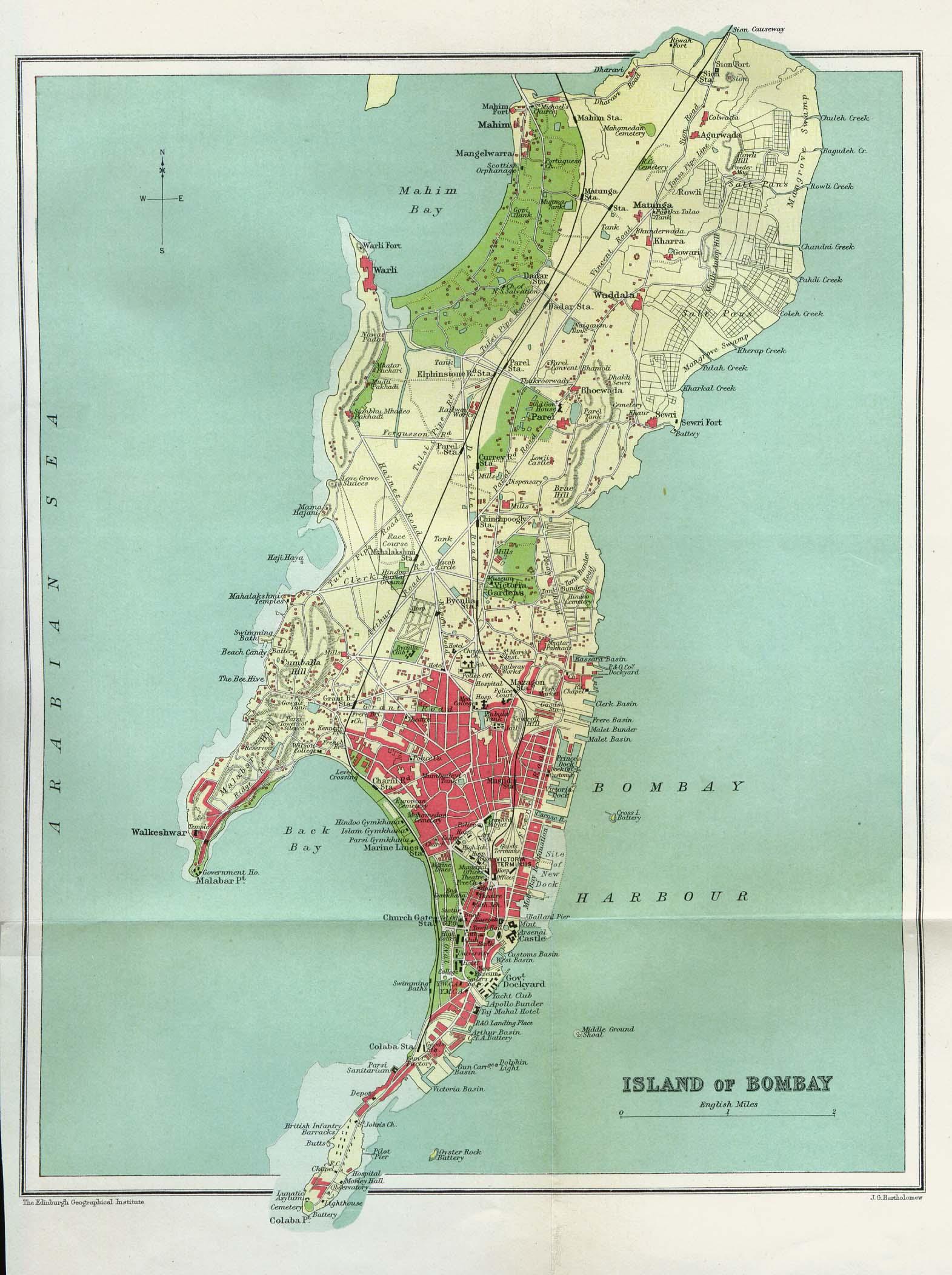
The Mumbai - Bombay vintage map give a unique insight into the history and evolution of Mumbai - Bombay city. This vintage map of Mumbai - Bombay with its antique style will allow you to travel in the past of Mumbai - Bombay in Maharashtra - India. The Mumbai - Bombay vintage map is downloadable in PDF, printable and free.
Mumbai-Bombay is built on what was once an archipelago of seven islands as its mentioned in Mumbai - Bombay vintage map: Bombay Island, Parel, Mazagaon, Mahim, Colaba, Worli, and Old Woman Island (also known as Little Colaba). It is not exactly known when these islands were first inhabited. Pleistocene sediments found along the coastal areas around Kandivali in northern Mumbai by archaeologist Todd in 1939 suggest that the islands were inhabited since the Stone Age. Perhaps at the beginning of the Common era (2000 years ago), or possibly earlier, they came to be occupied by the Koli fishing community.
In the third century BCE, the islands formed part of the Maurya Empire, during its expansion in the south, ruled by the Buddhist emperor, Ashoka of Magadha as its mentioned in Mumbai - Bombay vintage map. The Kanheri Caves in Borivali were excavated in the mid-third century BCE, and served as an important centre of Buddhism in Western India during ancient Times. The city then was known as Heptanesia to the Greek geographer Ptolemy in 150 CE. Between the second century BCE and ninth century CE, the islands came under the control of successive indigenous dynasties: Satavahanas, Western Kshatrapas, Abhiras, Vakatakas, Kalachuris, Konkan Mauryas, Chalukyas and Rashtrakutas, before being ruled by the Silhara dynasty from 810 to 1260. Some of the oldest edifices in the vintage city built during this period are, Jogeshwari Caves, Elephanta Caves (between the sixth to seventh century), Walkeshwar Temple (10th century), and Banganga Tank (12th century).
King Bhimdev founded his kingdom in the region in the late 13th century, and established his capital in Mahikawati (present day Mahim). The Pathare Prabhus, one of the earliest known settlers of the city, were brought to Mahikawati from Saurashtra in Gujarat around 1298 by Bhimdev. The Delhi Sultanate annexed the islands in 1347–48, and controlled it till 1407 as its shown in Mumbai - Bombay vintage map. During this time, the islands were administered by the Muslim Governors of Gujarat, who were appointed by the Delhi Sultanate. The islands were later governed by the independent Gujarat Sultanate, which was established in 1407. The Sultanate patronage led to the construction of many mosques, prominent being the Haji Ali Dargah in Worli, built in honour of the Muslim saint Haji Ali in 1431. From 1429 to 1431, the islands were a source of contention between the Gujarat Sultanate and the Bahamani Sultanate of Deccan.